
Defense & Maritime Security
Our seafloor intelligence technology empowers defense and security stakeholders with valuable insights to strengthen situational awareness, operational resilience, and national security.
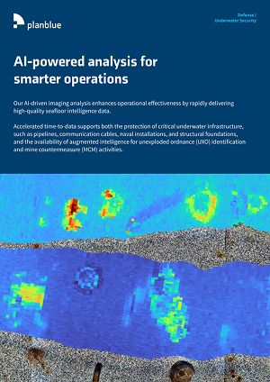
AI-powered analysis for smarter operations
Our AI-driven imaging analysis enhances operational effectiveness by rapidly delivering high-quality seafloor intelligence data. Accelerated time-to-data supports both the protection of critical underwater infrastructure, such as pipelines, communication cables, naval installations, and structural foundations, and the availability of augmented intelligence for unexploded ordnance (UXO) identification and mine countermeasure (MCM) activities. By reducing data delivery times from weeks to days or hours, we support more timely and informed decision-making in dynamic maritime security and defense environments.
Find more information in our handout!

PlanBlue’s subsea mapping capabilities can be used to support a range of defense and security use cases, including:
Intelligence, Surveillance, and Reconnaisance (ISR)
High-resolution, geo-referenced characterization of physical, biological, and geological seafloor conditions provides intelligence that feeds into ISR for naval and undersea operations. Fused RGB and hyperspectral imaging can improve the identification and classification of natural and artificial seabed anomalies, including UXO, mine-like objects (MLOs), and disturbed sediments. This persistent (environmental) baseline supports MCM planning, terrain assessment, and evaluation of seabed suitability for subsea operations and installations.
Cost Efficient & Sustainable operations
Fused optical data (RGB and hyperspectral) are captured in a single deployment, which allows for multiple mission objectives to be addressed simultaneously. Environmental characterization, UXO/MCM-relevant anomaly detection, infrastructure inspection, and impact assessment can be derived from one dataset, reducing the need for multiple surveys. This approach can minimize vessel days, dive time, and redeployments, thereby lowering operational costs while reducing environmental footprint and supporting sustained ISR operations.
Infrastructure Installation & Surveillance Planning
Precise seabed mapping supports mission planning and execution for the deployment of critical subsea infrastructure such as communications cables, sonar arrays, power systems, and fixed surveillance platforms. Integrated seafloor intelligence can reduce uncertainty, supports avoidance of UXO-contaminated or geotechnically unsuitable areas, and thereby lowers operational risk. The result is improved placement accuracy and enhanced long-term system performance in complex maritime environments.
Subsea Asset Protection & Integrity Monitoring
Persistent monitoring enables early detection of environmental or physical changes that may indicate wear, disturbance, interference, or sabotage. Repeated observations support integrity assessment of fiber-optic cables, power lines, foundations, and sensor networks, strengthening force protection and infrastructure resilience. Integrated into ISR workflows, our intelligence can function as an early-warning indicator for both natural degradation and hostile activity.
Marine Domain Awareness (MDA)
AI-driven data reanalysis can detect subtle changes in seabed conditions and benthic ecosystems that may indicate non-cooperative or illicit activity. Indicators include unauthorized seabed installations, covert anchoring, trafficking routes, illegal dumping, or disturbance signatures associated with UXO interaction or mine emplacement. This (environmental) intelligence layer can augment traditional ISR assets and enhances situational awareness in the undersea domain.
Visual Reporting & Intelligence Products
Operationally relevant visual reporting supports briefings, mission debriefs, compliance documentation, and inter-agency coordination. High-fidelity outputs provide digitally traceable, auditable records aligned with defense governance, accountability, and information-sharing requirements, improving clarity and decision-making across stakeholders.
Fully-automated seafloor intelligence for smarter maritime surveys.
We made cookies. Would you like some?
We use Google Analytics to improve your website experience and YouTube to show you video content. By clicking "Accept" you are agreeing to the placement and use of cookies as described in our Privacy Policy. Thanks for reading and enjoy your stay on our website.